Filters
No categories available
No brands available
Media

Appalachian Trail Data Book 2023
Appalachian Trail ConservancyAn essential planning and on-the-trail tool for thru- or section-hikers, the 2023 Appalachian Trail Data Book from the Appalachian Trail Conservancy is a lightweight guide to key features on the AT.
North America Hiking GuidebooksAppalachian Trail Hiking Guidebooks

Appalachian Trail Guide Set 7: Shenandoah National Park
PATCCombining a pocket-size trail guide and corresponding maps, the PATC Appalachian Trail Guide Set 7: Shenandoah National Park is your guide to all the trails in the park.
North America Hiking GuidebooksAppalachian Trail Hiking Guidebooks

Appalachian Trail Guide to Central Virginia Book and Maps Set
Appalachian Trail ConservancyCovering 226 miles—from Waynesboro to Pearisburg—this fourth edition of the Appalachian Trail Guide to Central Virginia Book and Maps Set includes a pocket-sized planning guide and 4 maps.
North America Hiking GuidebooksAppalachian Trail Hiking Guidebooks

Appalachian Trail Guide to Massachusetts-Connecticut Book and Maps Set
Appalachian Trail ConservancyExplore the lush woods and rocky streams of southern New England with this Appalachian Trail Guide to Massachusetts-Connecticut book and maps set. It covers 140.9 mi. between Vermont and New York.
North America Hiking GuidebooksAppalachian Trail Hiking Guidebooks

Appalachian Trail Guide: New York - New Jersey - 17th Edition - Guidebook and Maps
Appalachian Trail ConservancyThe updated edition of Appalachian Trail Guide: New York - New Jersey includes 2 water-resistant topo maps.
North America Hiking GuidebooksAppalachian Trail Hiking Guidebooks

Appalachian Trail Map Pack: Georgia, North Carolina and Tennessee
National GeographicThis Appalachian Trail map pack covers Georgia, North Carolina and Tennessee, tracing the trail from its southern terminus at Springer Mountain to Damascus on the Tennessee/Virginia state line.

Appalachian Trail Map Pack: Maine
National GeographicThis Appalachian Trail map pack covers the entirety of the trail in Maine, which offers some of the most challenging sections of the AT, both in terms of rugged terrain and weather conditions.

Appalachian Trail Map Pack: New Jersey, New York, Connecticut, Massachusetts
National GeographicThis Appalachian Trail map pack covers New Jersey, New York, Connecticut and Massachusetts, following the trail from the Pennsylvania border in the south to the Vermont state line in the north.
North America MapsNew England and Mid Atlantic Maps - DEPRECATED

Appalachian Trail Map Pack: Pennsylvania
National GeographicThe Appalachian Trail (AT) map pack for Pennsylvania covers the entire AT in the Keystone State. These maps follow the ridges of the Appalachian Mountains as the trail weaves in and out of suburbia.
North America MapsNew England and Mid Atlantic Maps - DEPRECATED

Appalachian Trail Map Pack: Vermont and New Hampshire
National GeographicThis Appalachian Trail map pack covers Vermont and New Hampshire—adjacent states with distinctly different landscapes ranging from wooded, rolling terrain to rugged and rocky high country.
North America MapsNew England and Mid Atlantic Maps - DEPRECATED

Appalachian Trail Map Pack: Virginia, West Virginia, Maryland
National GeographicThis Appalachian Trail map pack covers Virginia, West Virginia and Maryland, from the Tennessee/Virginia state line to the southern border of Pennsylvania.
North America MapsNew England and Mid Atlantic Maps - DEPRECATED
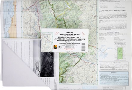
Appalachian Trail Map: AT and Other Trails in George Washington & Jefferson National Forests
PATCThis map covers sections 17 to 22 of the Appalachian Trail in Virginia, from Virginia Tye River to the James River Face Wilderness in the Glenwood-Pedlar District.
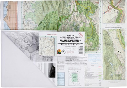
Appalachian Trail Map: AT and Other Trails in George Washington National Forest
PATCReady to explore the wilds of Virginia? The PATC Appalachian Trail Map 12 covers sections 15–17 in VA, from the Virginia Rockfish Gap to Tye River in the Glenwood-Pedlar District.
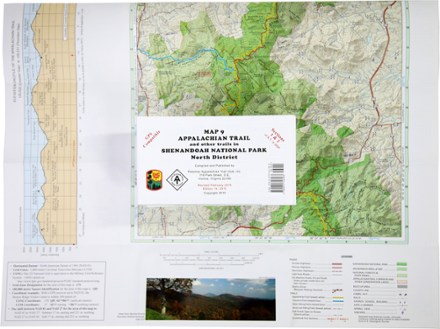
Appalachian Trail Map: AT and Other Trails in Shenandoah National Park North District
PATCThis map covers sections 1 and 2 of the Appalachian Trail—and all side trails—in Shenandoah National Park's North District.