Filters
No categories available
No brands available
Southeast Maps

Map F - Trails in Great North Mountain: Lee Ranger District to Virginia and West Virginia
PATCCovering the George Washington National Forest along the Virginia/West Virginia state line, PATC Map F highlights sections 16, 17, 18 and 19 of the Tuscarora Trail
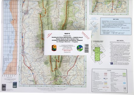
Map G - Trails in the Massanutten Mountain: Signal Knob to New Market Gap
PATCCovering an area from Signal Knob to New Market Gap, PATC Map G details sections 19 to 22 of the Tuscarora Trail in George Washington National Forest and the 72-mile Massanutten Trail.

Marco Island and Ten Thousand Islands Coastal Recreation Map
National GeographicLet the National Geographic Marco Island and Ten Thousand Islands Coastal Recreation Map guide you, both on land and on water, in this popular recreation area just outside of Everglades National Park.

Massanutten and Great North Mountain Trail Map
National GeographicThis National Geographic Trails Illustrated folded map offers comprehensive coverage of he Massanutten and Great North Mountain area of Virginia.

Mississippi Atlas and Gazetteer
DeLormeFrom its namesake river in the west to the Tombigbee and Pascagoula Rivers in the east—and everything between—the DeLorme Mississippi Atlas and Gazetteer covers the Magnolia State in fine detail.

Mount Rogers High Country Map
National GeographicThe National Geographic Trails Illustrated Mount Rogers High Country map offers detailed coverage of the landscapes and sweeping vistas found in Virginia's Grayson Highlands State Park.
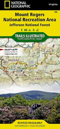
Mount Rogers National Recreation Area Map
National GeographicThis Trails Illustrated folded map offers comprehensive coverage of the Mount Rogers National Recreation Area in Virginia.

Nantahala and Cullasaja Gorges Trail Map
National GeographicThis National Geographic Trails Illustrated folded map offers comprehensive coverage of the Nantahala and Cullasaja Gorges area of North Carolina.

North Carolina Atlas and Gazetteer
DeLormeThe beautifully crafted DeLorme North Carolina Atlas and Gazetteer covers the entire state in fine detail so you can explore back roads, go sightseeing and plan your outdoor recreation trip with ease.

Okefenokee National Wildlife Refuge Topographic Map
National GeographicThe Trails Illustrated Okefenokee National Wildlife Refuge topographic map covers 630 square miles in southeast Georgia, encompassing nearly all of the world-renowned Okefenokee Swamp.
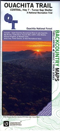
Ouachita Trail Central Map: Highway 7-Turner Gap Shelter
See the best of the Ozarks! One of 3 maps covering this trail, the Ouachita Trail Western topographic hiking map covers the western section of the trail from Talimena State Park to Turner Gap shelter.
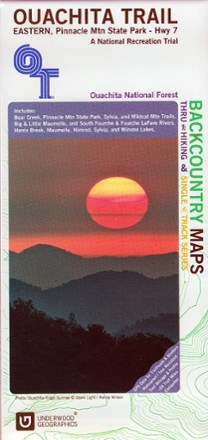
Ouachita Trail Eastern Map: Pinnacle Mountain State Park-Highway 7
See the best of the Ozarks! One of 3 maps covering this trail, the Ouachita Trail Eastern topographic hiking map covers the eastern section of the trail from Pinnacle Mountain State Park to Highway 7.

Ouachita Trail Western Map: Talimena State Park-Turner Gap Shelter
See the best of the Ozarks! One of 3 maps covering this trail, the Ouachita Trail Western topographic hiking map covers the western section of the trail from Talimena State Park to Turner Gap shelter.

Pikes Peak / Canon City Topographic Map
National GeographicThe Trails Illustrated Pikes Peak / Canon City topographic map offers detailed coverage of the highest summit in the southern Front Range of the Rocky Mountains.