
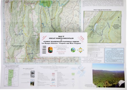
Map F - Trails in Great North Mountain: Lee Ranger District to Virginia and West Virginia
Tech Specs
Specifications are maintained on Pack4Back GearDB (community edits and revision history). Values may differ from the manufacturer or your unit—verify before buying.
BrandPATC
Best UseHiking
State / ProvinceVirginia
Folded Dimensions8 x 4 inches
Unfolded Dimensions27.5 x 22.5 inches
Map Scale1:62,400
PublisherPotomac Appalachian Trail Club
Copyright Year2001
Description
Covering the George Washington National Forest along the Virginia/West Virginia state line, PATC Map F highlights sections 16, 17, 18 and 19 of the Tuscarora Trail
Features
- Covers an area from Capon Springs and Wardensville to Bryce Ski Resort and Orkney Springs.
- Highlights sections 16, 17, 18 and 19 of the Tuscarora Trail, a distance of 31.1 miles
- Printed on water- and tear-resistant synthetic stock in 6 colors for excellent detail and durability
- 5 km full UTM grid permits easy plotting or extraction of coordinates for use with GPS units
- Provides an enlargement of the Trout Pond Recreation Area
- Includes an elevation profile of the Tuscarora Trail from Capon Run Road To Fetzer Gap
- Scale of 1:62,400; contour intervals of 100 feet