Filters
No categories available
No brands available
Media
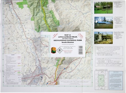
Appalachian Trail Map: AT and Other Trails in Shenandoah National Park South District
PATCThis map covers sections 6, 7, 8 and 9 of the Appalachian Trail—and all side trails—in Shenandoah National Park's South District.
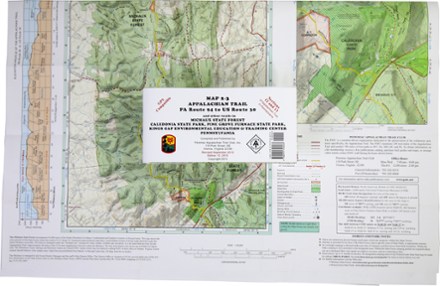
Appalachian Trail Map: PA Route 94 to US Route 30 and Other Trails
PATCReady to explore Pennsylvania? The PATC Appalachian Trail Map 2–3 of PA Route 94 to US Route 30 covers sections 12 and 13 of the state's Appalachian Trail in full color.

Appalachian Trail Map: Susquehanna River to PA Route 94 and Other Trails in Cumberland Valley
PATCReady to explore Pennsylvania? This PATC Appalachian Trail Map 1 of the Susquehanna River to PA Route 94 covers sections 9, 10 and 11 of the state's Appalachian Trail in full color.

Appalachian Trail Map: US Route 30 to PA-MD State Line and Other Trails
PATCReady to explore Pennsylvania? This PATC Appalachian Trail Map 4 of US Route 30 to PA-MD State Line covers section 14 of the state's Appalachian Trail in full color.

Appalachian Trail North Carolina-Georgia Guidebook and Maps Set
Appalachian Trail ConservancyConfidently navigate 238 mi. of the Appalachian Trail with the North Carolina-Georgia guidebook and maps set, from the eastern end of the Great Smoky Mountains to Springer Mountain, GA.
North America Hiking GuidebooksAppalachian Trail Hiking Guidebooks
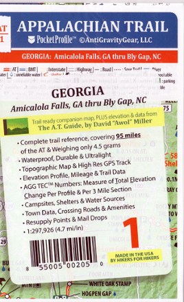
Appalachian Trail Pocket Profile Map: Georgia (Amicalola Falls, GA - Bly Gap, NC)
AntiGravityGearWeighing just 4.5g, the AT-1 Appalachian Trail Pocket Profile Map: Georgia from AntiGravityGear is an information-rich strip map to guide you on your AT hike through the Peach State.

Appalachian Trail Pocket Profile Map: Maine (Monson, ME - Katahdin, ME)
AntiGravityGearWeighing just 4.5g, the AT-22 Appalachian Trail Pocket Profile Map: Maine from AntiGravityGear is an information-rich strip map to guide you on your hike up to the Northern terminus of the AT.
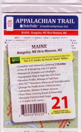
Appalachian Trail Pocket Profile Map: Maine (Rangeley, ME - Monson, ME)
AntiGravityGearWhether you're a thru-hiker or a section hiker, the AT-21 Appalachian Trail Pocket Profile Map for Maine (Rangeley to Monson) from AntiGravityGear provides the intel you need for a successful trek.
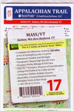
Appalachian Trail Pocket Profile Map: Massachusetts/Vermont (Dalton, MA - Rutland, VT)
AntiGravityGearWeighing just 4.5g, the AT-17 Appalachian Trail Pocket Profile Map: Massachusetts/Vermont from AntiGravityGear is an information-rich strip map to guide you on your AT hikes in the Northeast.
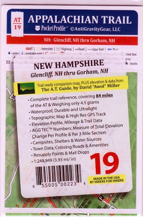
Appalachian Trail Pocket Profile Map: New Hampshire (Glencliff, NH - Gorham, NH)
AntiGravityGearWeighing just 4.5g, the AT-19 Appalachian Trail Pocket Profile Map: New Hampshire from AntiGravityGear is an information-rich strip map to guide you on your AT hike in the Granite State.
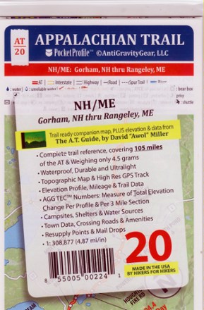
Appalachian Trail Pocket Profile Map: New Hampshire/Maine (Gorham, NH - Rangeley, ME)
AntiGravityGearWhether you're a thru-hiker or a section hiker, AT-20 Appalachian Trail Pocket Profile Map (Gorham, NH, to Rangeley, ME) from AntiGravityGear provides the intel you need for a successful trek.

Appalachian Trail Pocket Profile Map: New Jersey/New York (Unionville, NY - Pawling, NY)
AntiGravityGearWeighing just 4.5 g, the AT-15 Appalachian Trail Pocket Profile Map: NJ/NY from AntiGravityGear is a waterproof, tear-resistant, information-rich strip map to guide you on the AT in the mid-Atlantic.

Appalachian Trail Pocket Profile Map: New York/Connecticut/Massachusetts (Pawling, NY - Dalton, MA)
AntiGravityGearWeighing just 4.5g, the AT-16 Appalachian Trail Pocket Profile Map: NY/Conn/Mass from AntiGravityGear is an information-rich strip map to guide you on your AT hikes in the Northeast.
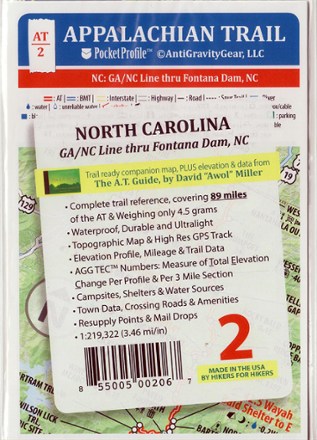
Appalachian Trail Pocket Profile Map: North Carolina (GA/NC Line - Fontana Dam, NC)
AntiGravityGearWeighing just 4.5g, the AT-2 Appalachian Trail Pocket Profile Map: North Carolina from AntiGravityGear is an information-rich strip map to guide you on your AT hike through the Old North State.