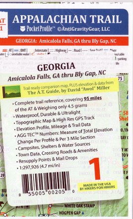
Appalachian Trail Pocket Profile Map: Georgia (Amicalola Falls, GA - Bly Gap, NC)
Tech Specs
Specifications are maintained on Pack4Back GearDB (community edits and revision history). Values may differ from the manufacturer or your unit—verify before buying.
BrandAntiGravityGear
Best UseHiking
State / ProvinceGeorgia
Folded Dimensions6.7 x 3.9 inches
Unfolded Dimensions17 x 3.9 inches
Map Scale1:297,926
Double SidedYes
WaterproofYes
PublisherAntiGravityGear
Map NumberAT-1
Description
Weighing just 4.5g, the AT-1 Appalachian Trail Pocket Profile Map: Georgia from AntiGravityGear is an information-rich strip map to guide you on your AT hike through the Peach State.
Features
- The map imagery includes a high-resolution GPS track, topographic maps, accurate road crossings and a bird's-eye view of points along the trail
- The elevation profile side includes trail mileage, shelter locations, camp sites, water sources, resupply points, lodging, outfitters, post offices and much more
- Printed in beautiful, vibrant colors on waterproof and tear-resistant material; folds into shirt pocket size for easy use
- Covers 95 miles of the Appalachian Trail in the state of Georgia, from Amicalola Falls to Bly Gap, North Carolina