Filters
No categories available
No brands available
New England And Mid Atlantic Maps Deprecated
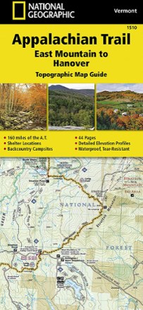
Appalachian Trail: East Mountain to Hanover Topographic Map Guide
National GeographicThe National Geographic Appalachian Trail: East Mountain to Hanover topographic map guide makes a perfect traveling companion when traversing the Vermont section of the Appalachian Trail.
North America MapsNew England and Mid Atlantic Maps - DEPRECATED
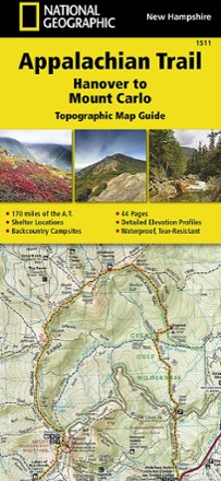
Appalachian Trail: Hanover to Mount Carlo Topographic Map Guide
National GeographicThe National Geographic Appalachian Trail: Hanover to Mount Carlo topographic map guide makes a perfect traveling companion when traversing the New Hampshire section of the Appalachian Trail.
North America MapsNew England and Mid Atlantic Maps - DEPRECATED
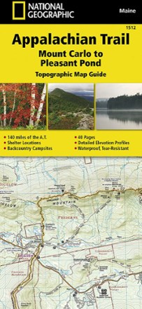
Appalachian Trail: Mount Carlo to Pleasant Pond Topographic Map Guide
National GeographicBring along the detailed National Geographic Mount Carlo to Pleasant Pond topographic map guide when you traverse the southern Maine section of the Appalachian Trail.
North America MapsNew England and Mid Atlantic Maps - DEPRECATED
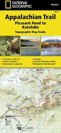
Appalachian Trail: Pleasant Pond to Katahdin Topographic Map Guide
National GeographicThe National Geographic Appalachian Trail: Pleasant Pond to Katahdin Topographic Map Guide makes a perfect traveling companion when traversing the northern Maine section of the Appalachian Trail.
North America MapsNew England and Mid Atlantic Maps - DEPRECATED

Appalachian Trail: Raven Rock to Swatara Gap Topographic Map Guide
National GeographicThe National Geographic Appalachian Trail: Raven Rock to Swatara Gap Topographic Map Guide makes a perfect companion when traversing the southeastern Pennsylvania section of the Appalachian Trail.
North America MapsNew England and Mid Atlantic Maps - DEPRECATED

Appalachian Trail: Schaghticoke Mountain to East Mountain Topographic Map Guide
National GeographicBring the National Geographic Appalachian Trail: Schaghticoke Mountain to East Mountain topographic map guide on your thru-hike of the Connecticut and Massachusetts sections of the Appalachian Trail.
North America MapsNew England and Mid Atlantic Maps - DEPRECATED
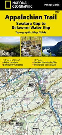
Appalachian Trail: Swatara Gap to Delaware Water Gap Topographic Map Guide
National GeographicBring the detailed National Geographic Appalachian Trail: Swatara Gap to Delaware Water Gap topographic map guide when traversing the northeastern Pennsylvania section of the Appalachian Trail.
North America MapsNew England and Mid Atlantic Maps - DEPRECATED

Baxter State Park Topographic Map
National GeographicThe Trails Illustrated Baxter State Park Topographic Map combines unmatched detail with helpful information to offer an invaluable tool for making the most of your visit.
North America MapsNew England and Mid Atlantic Maps - DEPRECATED

Blue Ridge Parkway Destination Map
National GeographicThe National Geographic Blue Ridge Parkway Destination Map guides you along this winding route that traverses some of America's most picturesque scenery.
North America MapsNew England and Mid Atlantic Maps - DEPRECATED

Boston Harbor Islands National Recreation Area Topographic Map
National GeographicThe Trails Illustrated Boston Harbor Islands National Recreation Area topographic map is an essential travel companion for visitors enjoying this area's abundant recreational opportunities.
North America MapsNew England and Mid Atlantic Maps - DEPRECATED
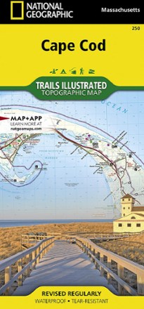
Cape Cod National Seashore Trail Map
National GeographicThis Trails Illustrated folded map offers comprehensive coverage of Cape Cod National Seashore in Massachusetts.
North America MapsNew England and Mid Atlantic Maps - DEPRECATED
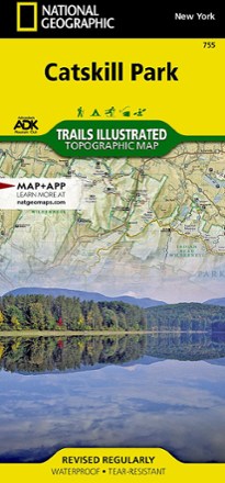
Catskill Park Trail Map
National GeographicThe Trails Illustrated Catskill Park trail map from National Geographic offers detailed coverage of New York's Catskill Park, from Bearhead Spring Mountain to Vernooy Kill Forest.
North America MapsNew England and Mid Atlantic Maps - DEPRECATED

East Hudson Trails Map Set - 12th Edition
New York New Jersey TrailExplore the rich forests of the Hudson Highlands with the 12th edition of the East Hudson Trails map set. This 3-map set features more than 150 miles of trails.
North America MapsNew England and Mid Atlantic Maps - DEPRECATED

Franconia Notch/North Conway Trail Map
National GeographicThis detailed National Geographic Trails Illustrated folded map offers comprehensive coverage of Franconia Notch and Lincoln in New Hampshire.
North America MapsNew England and Mid Atlantic Maps - DEPRECATED