

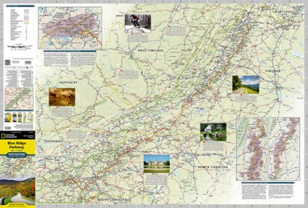
Blue Ridge Parkway Destination Map
Tech Specs
Specifications are maintained on Pack4Back GearDB (community edits and revision history). Values may differ from the manufacturer or your unit—verify before buying.
Description
The National Geographic Blue Ridge Parkway Destination Map guides you along this winding route that traverses some of America's most picturesque scenery.
Features
- Combining the Parkway and Skyline Drive through Shenandoah National Park, this map and guide covers a travel experience of almost 600 miles
- Contains comprehensive road networks, infrastructure and natural, historical and cultural places
- Stunning photography and valuable travel tips inspire travelers and help with pre-trip planning and on-the-ground adventures
- 1:800,000 scale
- Printed in the USA on a durable, lightweight, waterproof and tear-resistant material designed to withstand the rigors of travel
- Folded dimensions: 4.25 x 9.25 in.; Unfolded dimensions: 25.5 x 37.75 in.
- National Geographic Maps; copyright 2015