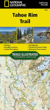


Tahoe Rim Trail Topographic Map Guide
Tech Specs
Specifications are maintained on Pack4Back GearDB (community edits and revision history). Values may differ from the manufacturer or your unit—verify before buying.
BrandNational Geographic
Best UseBackpacking
State / ProvinceCalifornia
Folded Dimensions9.25 x 4.25 inches
Unfolded DimensionsUnavailable
Map Scale1:63,360
Double SidedYes
WaterproofYes
PublisherNational Geographic
Copyright Year2018
Map Number1013
Description
The Tahoe Rim Trail traverses some of the most spectacular scenery in the Sierra Nevada and Carson Ranges. Use the Trails Illustrated Tahoe Rim Trail topographic map guide to find your way.
Features
- As it circumnavigates the beautiful Lake Tahoe Basin, the 175-mile Tahoe Rim Trail (TRT) climbs high peaks, offers tremendous views and dips in and out of flowery meadows
- This map guide is arranged for clockwise travel around the Tahoe Rim Trail starting at Tahoe City
- Each map page has a detailed trail profile that shows the elevation changes you will encounter
- The TRT is highlighted and centered on each page so you can easily track your progress
- Guide also includes detailed information about the 8 standard sections of the TRT; each section is from 15 to 30 miles and covers about 2 pages of the map guide
- More convenient and easier to use than folded maps, but just as compact and lightweight, the 40-page map guide booklet is printed on waterproof, tear-resistant paper
- A full UTM grid is printed on the map to aid with GPS navigation