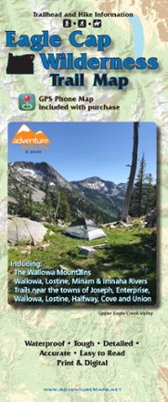
Eagle Cap Wilderness Trail Map - 2020
Tech Specs
Specifications are maintained on Pack4Back GearDB (community edits and revision history). Values may differ from the manufacturer or your unit—verify before buying.
BrandAdventure Maps
Best UseHiking
State / ProvinceOregon
Folded DimensionsUnavailable
Map Scale1:63,360
WaterproofYes
PublisherAdventure Maps, Inc.
Copyright Year2020
Description
The Eagle Cap Wilderness Trail Map is a waterproof, topographic (lat/long, UTM grids) trail map that includes hiking descriptions covering the Wallowa Mountains, including the Eagle Cap Wilderness.
Features
- The Wallowa Mountains and the Eagle Cap Wilderness are an area dominated by high granite peaks, rolling ridgelines, alpine lakes and numerous clear mountain streams
- The trails along this range allow opportunities for truly outstanding trips from just a few hours to days or weeks
- There is no mountain biking in any wilderness, but there are some mountain biking opportunities in the foothills of the Wallowas outside the wilderness boundary
- Includes hiking descriptions and details for the 27 trailheads in the area
- Equestrians and anglers will also find this map very useful as it accurately shows all streams, lakes, roads and land ownership boundaries
- The trailhead information will help point you in the direction best suited to your abilities and interests
- $0.50 of each map sale is donated to the Wallowas Mountains Hells Canyon Trails Association to be used for trail maintenance projects