Pine Mountain Trail Map
Tech Specs
Specifications are maintained on Pack4Back GearDB (community edits and revision history). Values may differ from the manufacturer or your unit—verify before buying.
Description
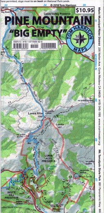
This waterproof and tear-resistant folded map of Pine Mountain provides detailed and accurate trail information.
Features
- Map features color-coded symbols and trails, mileages between trail junctions, contour lines, vegetation and elevations at trail junctions
- Also features latitude/longitude and UTM grids, making map compatible with GPS users
- Covers Loma Alta, Gary Giacomini, Roy's Redwoods French Ranch, White Hill, Cascade Canyon, Marin Municipal Water District and Audubon Canyon Ranch
- Printed on waterproof, tear-resistant plastic for long-lasting use
- Measures 9 x 4.25 inches folded; folds out to 27 x 18 inches; scale of 1:24,000
- Provides key contact information and websites
- Tom Harrison Maps; copyright 2004