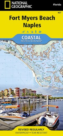


Fort Myers Beach and Naples Coastal Recreation Map
Tech Specs
Specifications are maintained on Pack4Back GearDB (community edits and revision history). Values may differ from the manufacturer or your unit—verify before buying.
BrandNational Geographic
Best UsePaddling
State / ProvinceFlorida
Folded Dimensions9.25 x 4.25 inches
Unfolded Dimensions37.75 x 25.5 inches
Map Scale1:40,000
Double SidedYes
WaterproofYes
PublisherNational Geographic
Copyright Year2013
Map Number407
Description
Let the National Geographic Fort Myers Beach and Naples Coastal Recreation map guide you, both on land and on water, along the shorelines of southwest Florida.
Features
- Map covers Estero Bay Preserve State Park and Aquatic Preserve, Lovers Key and Delnor-Wiggins Pass state parks and the Sanibel, Estero and Keewaydin Islands
- Shows Bonita and Naples Beaches, Imperial River, Big and Little Hickory Bays, Barefoot Beach Boulevard and Rookery Bay National Estuarine Research Reserve
- Also includes the J.N. Darling National Wildlife Refuge, the Gulf of Mexico and a complete road network from San Carlos Park to the city of Naples
- Follow the Great Calusa Blueway and a segment of the Florida Circumnavigational Saltwater Paddling Trail with your canoe, kayak or SUP
- Recreation highlights include campgrounds, RV campgrounds, boat launches, beaches, golf courses, dive sites and areas for picnicking, swimming, snorkeling and fishing
- A marina guide provides location, contact information, maximum boat sizes and various amenities; additional marine aids include day beacons, lights, buoys and sounding
- Provides QR codes for current weather information and U.S. Coast Guard updates
- Printed on durable synthetic paper, making the map waterproof, tear-resistant and tough; capable of withstanding the rigors of international travel
- A full UTM grid is printed on the map to aid with GPS and app navigation