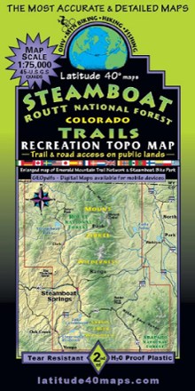
Steamboat - Routt National Forest Trails Map
Tech Specs
Specifications are maintained on Pack4Back GearDB (community edits and revision history). Values may differ from the manufacturer or your unit—verify before buying.
BrandLatitude 40 Maps
Best UseHiking
State / ProvinceColorado
Folded Dimensions8.4 x 4.2 inches
Unfolded Dimensions38.25 x 25.2 inches
Map Scale1:75,000 or 1 in. = 1.2 mi. or 2 km
Double SidedYes
WaterproofYes
PublisherLatitude 40 Maps
Copyright Year2020
Description
A recreational topo map covering the Routt National Forest trails near Steamboat Springs, Colorado, this 2-sided map displays the north half on one side and the south half on reverse side.
Features
- Includes Stagecoach State Park, Steamboat Lake State Park, Pearl Lake State Park, Mount Zirkel Wilderness, Sarvis Creek Wilderness and Troublesome WSA
- Continental Divide National Scenic Trail (CDT) from the Wyoming/Colorado border south to Poison Ridge
- Enlarged map of Steamboat Springs (Scale 1:37,500 or 1 in. = 0.6 mi. or 1.0 km.) shows the Emerald Mountain Trail Network and Steamboat Bike Park
- List of 63 trails/routes with difficulty ratings, distance, length and elevation gain/loss
- Also includes dozens of state wildlife areas, state trust lands, BLM lands, public-access trails and roads for all types of backcountry enthusiasts
- Latitude and longitude map borders; UTM coordinate grid