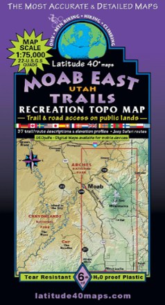
Moab East Utah Trails Map - 6th Edition
Tech Specs
Specifications are maintained on Pack4Back GearDB (community edits and revision history). Values may differ from the manufacturer or your unit—verify before buying.
BrandLatitude 40 Maps
Best UseHiking
Folded Dimensions8 x 4.2 inches
Unfolded Dimensions39.3 x 27 inches
Map Scale1:75,000
Double SidedYes
WaterproofYes
PublisherLatitude 40 Maps
Copyright Year2020
State / ProvinceColorado
Description
Explore the trails and roads of Moab East with the Latitude 40 Moab East Utah Trails Map, a full-color, waterproof topographic map leading you across an incredible stretch of eastern Utah.
Features
- Covers all or part of 42 USGS sites, bordering near I-70 to the north, Monticello, Utah to the south, the Colorado state line to the east and 2 miles west of Moab
- Includes 37 trail and route descriptions with mileage and elevation profiles to determine the scope of the adventure, as well as off-road routes
- Waterproof, tear-resistant plastic map with shade-relief contours provides durability in any conditions
- Includes UTM & Latitude/Longitude grids, and GPS coordinates to trails and roads for easy navigation