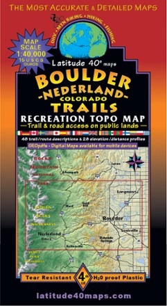
Boulder - Nederland Trails Map
Tech Specs
Specifications are maintained on Pack4Back GearDB (community edits and revision history). Values may differ from the manufacturer or your unit—verify before buying.
BrandLatitude 40 Maps
Best UseHiking
State / ProvinceColorado
Folded Dimensions8 x 4 inches
Unfolded Dimensions39 x 25 inches
Map Scale1:40,000; 1 inch = 0.63 mi. or 1.06 km
WaterproofYes
PublisherLatitude 40 Maps
Copyright Year2020
Description
A recreational topo map covering the beautiful terrain in and around Boulder County, Colorado, the Latitude 40 Maps Boulder - Nederland Trails map includes 48 trail descriptions for outdoor lovers.
Features
- North coverage includes St. Vrain Glaciers and Peaceful Valley; south coverage includes East Portal and Rollinsville
- East coverage includes Louisville; west coverage includes Devil's Thumb and Rollins Pass
- Includes the foothills east of the Peak to Peak highway
- Includes the east side of Indian Peaks Wilderness
- 20 elevation profiles