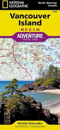


Vancouver Island, Canada, Map
Tech Specs
Specifications are maintained on Pack4Back GearDB (community edits and revision history). Values may differ from the manufacturer or your unit—verify before buying.
BrandNational Geographic
Best UseTravel
Folded Dimensions9.25 x 4.25 x 0.3 inches
Unfolded Dimensions37.75 x 25.5 inches
Map Scale1:2,100,000
Double SidedYes
WaterproofYes
PublisherNational Geographic
Copyright Year2020
State / ProvinceBritish Columbia
Map Number3128
Description
This National Geographic Vancouver Island Adventure Map provides global travelers with the perfect combination of detail and perspective in a highly functional travel tool.
Features
- Cities and towns are clearly indicated and easy to find in the user-friendly index
- A road network complete with distances and designations for roads, motorways and expressways will help you find the route that's right for you
- Secondary routes are also marked for those seeking to explore off the beaten path
- Hundreds of points of interest and diverse, unique destinations are highlighted
- These include national parks, nature reserves, World Heritage sites, archeological sites, ski areas, hot springs, beaches, museums and more
- The south side of the print map shows Victoria, the capital of British Columbia, as well as Pacific Rim National Park Reserve and the costal town of Nanaimo
- The northern half of the printed map covers the much more remote part of the island
- Printed on durable synthetic paper, making the map waterproof, tear-resistant and tough; capable of withstanding the rigors of international travel
- Your purchase helps support National Geographic Society nonprofit's mission of research, education, conservation and exploration