

Wasatch Front South Topographic Map
Tech Specs
Specifications are maintained on Pack4Back GearDB (community edits and revision history). Values may differ from the manufacturer or your unit—verify before buying.
Description
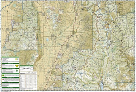
The Trails Illustrated Wasatch Front South topographic map is a comprehensive guide for outdoor enthusiasts enjoying the year-round recreation activities in this region.
Features
- Created in cooperation with the U.S. Forest Service and others, this map features key points of interest such as Goshen, Juab Valley, Strawberry Ridge and Wasatch Plateau
- Coverage includes Uinta and Manti-La Sal national forests, Mt. Nebo Wilderness, San Pitch Mountains, Joes Valley Reservoir and Lake Canyon Recreation Area
- Easy-to-read, yet highly detailed map shows comprehensive trail and road networks, along with designated trails for hiking, horseback riding, biking and more
- Clearly marked navigational aids with UTM coordinate grids, scale bar and full legend, essential for safely navigating the backcountry with GPS or compass
- Features key points of interest such as scenic views, campgrounds, trailheads, boat launches and picnic sites
- Color-coded boundaries for public lands including national parks, national forests, national monuments, ranger districts, wilderness areas, state parks and wildlife refuges
- 1:48,000 scale
- Folded dimensions: 4.25 x 9.25 in.; unfolded dimensions: 37.75 x 25.5 in.
- Printed in the USA on durable, lightweight, waterproof and tear-resistant material designed to withstand all weather conditions
- National Geographic Maps; copyright 2015