Filters
No categories available
No brands available
New England And Mid Atlantic Maps
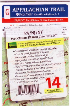
Appalachian Trail Pocket Profile Map: Pennsylvania/New Jersey/New York (Port Clinton, PA - Unionville, NY)
AntiGravityGearWeighing just 4.5g, the AT-14 Appalachian Trail Pocket Profile Map: PA/NJ/NY from AntiGravityGear is an information-rich strip map to guide you on your AT hike in the mid-Atlantic.
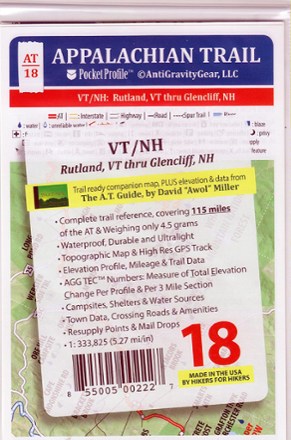
Appalachian Trail Pocket Profile Map: Vermont/New Hampshire (Rutland, VT - Glencliff, NH)
AntiGravityGearWeighing just 4.5g, the AT-18 Appalachian Trail Pocket Profile Map: Vermont/New Hampshire from AntiGravityGear is an information-rich strip map to guide you on your AT hikes in the Northeast.
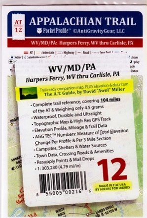
Appalachian Trail Pocket Profile Map: West Virginia/Maryland/Pennsylvania (Harpers Ferry, WV - Carlisle, PA)
AntiGravityGearWeighing just 4.5g, the AT-12 Appalachian Trail Pocket Profile Map: WV/MD/PA from AntiGravityGear is an information-rich strip map to guide you on your AT hike in the mid-Atlantic.
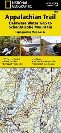
Appalachian Trail: Delaware Water Gap to Schaghticoke Mountain Topographic Map Guide
National GeographicThe National Geographic Appalachian Trail: Delaware Water Gap to Schaghticoke Mountain topographic map guide is a valuable reference for the New Jersey and New York sections of the Appalachian Trail.
North America MapsNew England and Mid Atlantic Maps - DEPRECATED
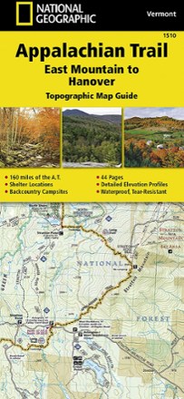
Appalachian Trail: East Mountain to Hanover Topographic Map Guide
National GeographicThe National Geographic Appalachian Trail: East Mountain to Hanover topographic map guide makes a perfect traveling companion when traversing the Vermont section of the Appalachian Trail.
North America MapsNew England and Mid Atlantic Maps - DEPRECATED
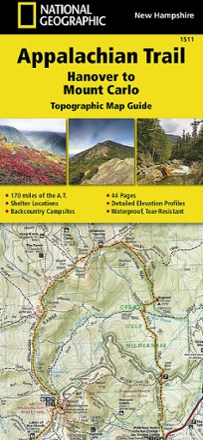
Appalachian Trail: Hanover to Mount Carlo Topographic Map Guide
National GeographicThe National Geographic Appalachian Trail: Hanover to Mount Carlo topographic map guide makes a perfect traveling companion when traversing the New Hampshire section of the Appalachian Trail.
North America MapsNew England and Mid Atlantic Maps - DEPRECATED
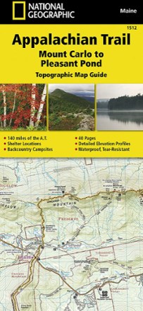
Appalachian Trail: Mount Carlo to Pleasant Pond Topographic Map Guide
National GeographicBring along the detailed National Geographic Mount Carlo to Pleasant Pond topographic map guide when you traverse the southern Maine section of the Appalachian Trail.
North America MapsNew England and Mid Atlantic Maps - DEPRECATED
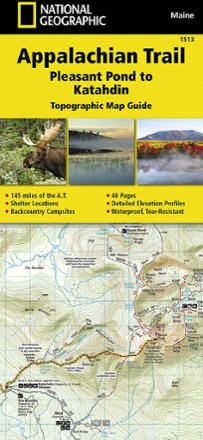
Appalachian Trail: Pleasant Pond to Katahdin Topographic Map Guide
National GeographicThe National Geographic Appalachian Trail: Pleasant Pond to Katahdin Topographic Map Guide makes a perfect traveling companion when traversing the northern Maine section of the Appalachian Trail.
North America MapsNew England and Mid Atlantic Maps - DEPRECATED

Appalachian Trail: Raven Rock to Swatara Gap Topographic Map Guide
National GeographicThe National Geographic Appalachian Trail: Raven Rock to Swatara Gap Topographic Map Guide makes a perfect companion when traversing the southeastern Pennsylvania section of the Appalachian Trail.
North America MapsNew England and Mid Atlantic Maps - DEPRECATED

Appalachian Trail: Schaghticoke Mountain to East Mountain Topographic Map Guide
National GeographicBring the National Geographic Appalachian Trail: Schaghticoke Mountain to East Mountain topographic map guide on your thru-hike of the Connecticut and Massachusetts sections of the Appalachian Trail.
North America MapsNew England and Mid Atlantic Maps - DEPRECATED
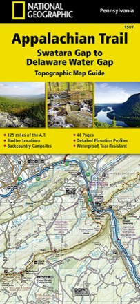
Appalachian Trail: Swatara Gap to Delaware Water Gap Topographic Map Guide
National GeographicBring the detailed National Geographic Appalachian Trail: Swatara Gap to Delaware Water Gap topographic map guide when traversing the northeastern Pennsylvania section of the Appalachian Trail.
North America MapsNew England and Mid Atlantic Maps - DEPRECATED
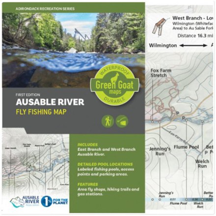
Ausable River Fly Fishing Map
Green Goat MapsDetailing the east and west branches of the Ausable River in New York's Adirondack Park, Green Goat Maps Ausable River Fly Fishing map was made for anglers, paddlers and river enthusiasts of all kind.

Bald Eagle Pennsylvania State Forest Map - 4th Edition
Purple Lizard MapsA map for people who love real-world experiences, the 4th edition of the Purple Lizard Maps Bald Eagle Pennsylvania State Forest map will help you plan your adventures in and around the area.

Baxter State Park Topographic Map
National GeographicThe Trails Illustrated Baxter State Park Topographic Map combines unmatched detail with helpful information to offer an invaluable tool for making the most of your visit.
North America MapsNew England and Mid Atlantic Maps - DEPRECATED