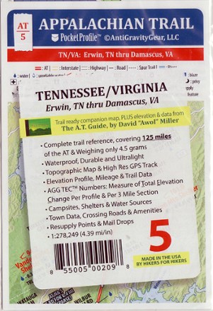
Appalachian Trail Pocket Profile Map: Tennessee/Virginia (Erwin, TN - Damascus, VA)
Tech Specs
Specifications are maintained on Pack4Back GearDB (community edits and revision history). Values may differ from the manufacturer or your unit—verify before buying.
BrandAntiGravityGear
Best UseHiking
State / ProvinceTennessee
Folded Dimensions6.7 x 3.9 inches
Unfolded Dimensions17 x 3.9 inches
Map Scale1:278,249
Double SidedYes
WaterproofYes
PublisherAntiGravityGear
Map NumberAT-5
Description
Weighing just 4.5g, the AT-5 Appalachian Trail Pocket Profile Map from AntiGravityGear is an information-rich strip map to guide you on your AT hike from Erwin, TN, to Damascus, VA.
Features
- The map imagery includes a high-resolution GPS track, topographic maps, accurate road crossings and a bird's-eye view of points along the trail
- The elevation profile side includes trail mileage, shelter locations, camp sites, water sources, resupply points, lodging, outfitters, post offices and much more
- Printed in beautiful, vibrant colors on waterproof and tear-resistant material; folds into shirt pocket size for easy use
- Covers 125 miles of the Appalachian Trail, from Erwin, Tennessee, to Damascus, Virginia