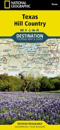


Texas Hill Country Destination Touring Map and Guide
Tech Specs
Specifications are maintained on Pack4Back GearDB (community edits and revision history). Values may differ from the manufacturer or your unit—verify before buying.
Description
The National Geographic Texas Hill Country Destination Touring map and guide strikes a balance between map and guidebook—perfect for touring this culturally and geographically unique region.
Features
- The front features a map of this region of central Texas whose southern border almost touches San Antonio and whose eastern border nudges up against Austin's suburbs
- Traversing 19 counties, the 800-mile Texas Hill Country Trail is outlined
- Reverse insets about Austin, museums, wineries and local culture, along with outdoor activities such as wildlife and wildflower viewing, hiking and caving and biking
- Double-sided design contains detailed maps and useful travel information
- Includes a comprehensive road network, local infrastructure and abundant natural, historical and cultural places
- Beautiful photographs and valuable travel information aid travelers with pre-trip planning and on-the-ground adventures
- Printed in the USA on durable, lightweight, waterproof and tear-resistant material designed to withstand all weather conditions
- Folded dimensions: 4.25 x 9.25 in.; Unfolded dimensions: 37.75 x 25.5 in.
- 1:578,640 scale
- National Geographic Maps; copyright 2013