Pocket Profile John Muir Trail and PCT Map
Tech Specs
Specifications are maintained on Pack4Back GearDB (community edits and revision history). Values may differ from the manufacturer or your unit—verify before buying.
Description
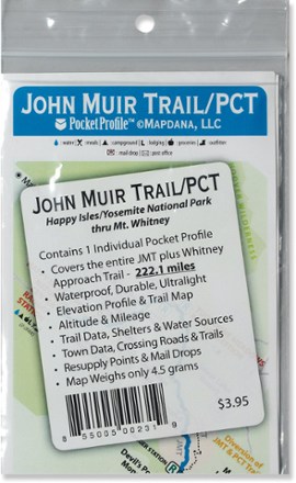
The Pocket Profile John Muir and PCT map from AntiGravityGear is the perfect-size companion for moment-by-moment reference when you're on the John Muir portion of the Pacfic Crest Trail.
Features
- Waterproof, durable and virtually weightless, the Pocket Profile features an overview map on one side and an elevation profile on the other
- Includes trail mileage, shelter locations, campsites, water sources, resupply points, lodging, outfitters, medical facilities, post offices and much more
- Covers 222.1 miles from Happy Isles/Yosemite National Park through the Mt. Whitney approach trail
- The Pocket Profile John Muir and PCT map unfolds from 5.75 x 4 in. to 15 x 4 in. and weighs 4.5g