
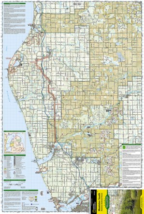
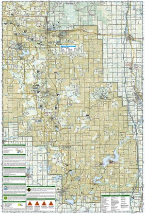
Manistee South Topographic Map
Tech Specs
Specifications are maintained on Pack4Back GearDB (community edits and revision history). Values may differ from the manufacturer or your unit—verify before buying.
Description
Explore the many recreational opportunities available year-round in Michigan's northern lower peninsula with the Trails Illustrated Manistee South topographic map.
Features
- Expertly researched and created in partnership with local land management agencies, this map delivers unmatched detail and helpful information
- Covers Silver Lake, Hart-Montague Trail, Newaygo, Muskegon, Mears and Duck Lake state parks, Pentwater River and parts of the White, Pere Marquette, and Muskegon rivers
- Easy-to-read, yet highly detailed map shows comprehensive trail and road networks, along with designated trails for hiking, horseback riding, biking and more
- Clearly marked navigational aids with UTM coordinate grids, scale bar and full legend, essential for safely navigating the backcountry with GPS or compass
- Features key points of interest such as scenic views, campgrounds, trailheads, boat launches and picnic sites
- Color-coded boundaries for public lands including national parks, national forests, national monuments, ranger districts, wilderness areas, state parks and wildlife refuges
- 1:75,000 scale
- Printed in the USA on durable, lightweight, waterproof and tear-resistant material designed to withstand all weather conditions
- Folded dimensions: 4.25 x 9.25 in.; unfolded dimensions: 25.5 x 37.75 in.
- National Geographic Maps; copyright 2012