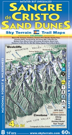
Sangre de Cristo and Great Sand Dunes Trail Map - 4th Edition
Tech Specs
Specifications are maintained on Pack4Back GearDB (community edits and revision history). Values may differ from the manufacturer or your unit—verify before buying.
Best UseHiking
Folded Dimensions8 x 4 inches
Unfolded Dimensions39 x 24 inches
Map Scale1:60,000
Double SidedYes
WaterproofYes
PublisherSky Terrain Trail Maps
Copyright Year2014
State / ProvinceColorado
Description
With an area that includes 8 Fourteeners and 53 Thirteeners, you'll find spectacular scenery on the trails with the pocket-size Sky Terrain Sangre de Cristo and Great Sand Dunes Trail Map.
Features
- Waterproof, tear-resistant map provides durability in all conditions, and can withstand years of use in hand and on the trail
- Area includes the Sangre de Cristo Mountains and Great Sand Dunes national park
- Map shows 8 Fourteeners that include Blanca, Crestone, Crestone Needle, Ellingwood, Humboldt, Kit Carson, Lindsey and Little Bear and includes 53 Thirteeners in the area
- Color-shaded topographic relief in 100 ft. and 500 ft. contours shows the vivid detail of the stunning mountain terrain
- Full UTM grid makes navigation easy with GPS and compass
- Includes descriptions to 50 trails, camping and park info, mileage between trail junctions and color-coded difficulty rating symbols
- Recreation-focused trails ideal for hiking, mountain biking, skiing, 4WD, motorcycle, hunting, camping, fishing and more
- Easy-to-read symbols indicate all campgrounds and trailheads in the area, as well as waterfalls, springs and more