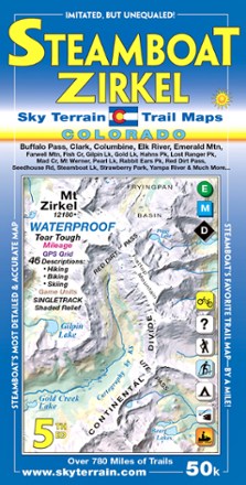
Steamboat Springs and Mount Zirkel Trail Map - 5th Edition
Tech Specs
Specifications are maintained on Pack4Back GearDB (community edits and revision history). Values may differ from the manufacturer or your unit—verify before buying.
Best UseHiking
Folded Dimensions8 x 4 inches
Unfolded Dimensions38.5 x 24 inches
Map Scale1:50,000
Double SidedYes
WaterproofYes
PublisherSky Terrain Trail Maps
Copyright Year2019
State / ProvinceColorado
Description
Waterproof and pocket-size, Sky Terrain Steamboat Springs and Mount Zirkel Trail Map highlights this stunning region of the Rockies with vividly detailed topography of the terrain and trails to trek.
Features
- Waterproof, tear-resistant map provides durability in all conditions, and can withstand years of use in hand and on the trail
- Covers Steamboat Springs, Mount Zirkel, Buffalo Pass, Clark, Columbine, Elk River, Emerald Mountain, Farwell Mountains, Buffalo Pass, Rabbit Ears Peak, Steamboat Lake and more
- Also takes you into Routt National Forest and Mt. Zirkel Wilderness
- Color-shaded topographic relief in 80 ft. and 400 ft. contours shows the vivid detail of the stunning mountain terrain
- Full UTM grid makes navigation easy with GPS and compass
- Information includes descriptions to 46 trails, mileage between trail junctions and color-coded difficulty rating symbols to simplify choosing your adventure
- 16 USGS quads (8 on each side) feature over 780 mi. of mapped trails
- Recreation-focused trails ideal for hiking, mountain biking, skiing, 4WD, motorcycle, camping, fishing and more
- Easy-to-read symbols indicate all campgrounds and trailheads in the area, as well as mining ghost towns, waterfalls and hot springs