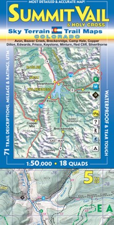
Summit Vail and Holy Cross Trail Map - 5th Edition
Tech Specs
Specifications are maintained on Pack4Back GearDB (community edits and revision history). Values may differ from the manufacturer or your unit—verify before buying.
Best UseNavigating
Folded Dimensions8 x 4 inches
Unfolded Dimensions39 x 27 inches
Map Scale1:50,000
Double SidedYes
WaterproofYes
PublisherSky Terrain Trail Maps
Copyright Year2019
State / ProvinceColorado
Description
Find your way around a stunning region of the Rockies with the Sky Terrain Summit Vail and Holy Cross Trail Map, highlighting the area with vivid accuracy and detail of the terrain and trails to trek.
Features
- Waterproof, tear-resistant map provides durability in all conditions, and is built to withstand years of use in hand and on the trail
- Covers Vail, Breckenridge, Dillon, Frisco, Minturn, Edwards, Red Cliff and more
- Access 2 Fourteeners (Mt. of the Holy Cross and Quandary Peak) and parts of Eagle Nest, Holy Cross and Ptarmigan Peak Wilderness
- Color-shaded topographic relief in 100 ft. and 500 ft. contours shows the vivid detail of the stunning, sweeping mountain terrain
- Full UTM grid makes navigation easy with GPS and compass
- Information includes descriptions to 71 trails, mileage between trail junctions and color-coded difficulty rating symbols to simplify choosing your adventure
- 18 USGS quads (9 on each side) feature over 1,170 mi. of mapped trails
- Recreation-focused trails ideal for hiking, mountain biking, 4WD, motorcycle, camping, fishing, skiing and more
- Easy-to-read symbols indicate all campgrounds and trailheads in the area, as well as mining ghost towns, waterfalls and hot springs