Art Loeb Trail Elevation Profile map
Tech Specs
Specifications are maintained on Pack4Back GearDB (community edits and revision history). Values may differ from the manufacturer or your unit—verify before buying.
BrandAntiGravityGear
Best UseHiking
State / ProvinceNorth Carolina
Folded Dimensions4 x 6 inches
Unfolded Dimensions4 x 18 inches
Map ScaleUnavailable
Double SidedYes
WaterproofYes
PublisherAntiGravity
Copyright Year2018
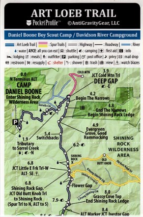
Description
Weighing just 4 g, the pocket-size Art Loeb Trail Elevation Profile map from AntiGravityGear is loaded with all at-a-glance information you need for hiking all 30.1 miles of this North Carolina trail.
Features
- Covers all 30.1 mi. of the Art Loeb Trail plus Cold Mountain, Old Butt Knob and Shining Creek spur trails
- Simple, easy-to read topographic representation of the terrain and trail features a map on one side and elevation profile with altitudes and trail data on the other
- Trail data includes mileage and GPS coordinates, access points and parking, noted camp shelters, water sources, town data, resupply points, crossing roads, and mail drops
- Pocket Profiles are waterproof, rub-resistant and tear-resistant to withstand the rigors of hiking in any condition
- Folds to pocket-size and weighs just 4 g, making it ideal for any pack