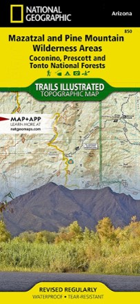


Mazatzal and Pine Mountain Wilderness Areas Topographic Map
Tech Specs
Specifications are maintained on Pack4Back GearDB (community edits and revision history). Values may differ from the manufacturer or your unit—verify before buying.
Description
Outdoor enthusiasts looking for recreational opportunities just north of Phoenix will marvel at the Trails Illustrated Mazatzal and Pine Mountain Wilderness Areas topographic map.
Features
- Expertly researched and created in cooperation with the U.S. Forest Service, Bureau of Land Management and others
- Covers Mazatzal and Pine Mountain wilderness areas in Coconino, Prescott and Tonto national forests with unmatched detail
- Includes Agua Fria National Monument, Verde River, Mogollon Rim, Bartlett and Horseshoe reservoirs, Mazatzal Mountains, Spur Cross Ranch and Tonto Natural Bridge State Park
- Easy-to-read, yet highly detailed map shows comprehensive trail and road networks, along with designated trails for hiking, horseback riding, biking and more
- Clearly marked navigational aids with UTM coordinate grids, scale bar and full legend, essential for safely navigating the backcountry with GPS or compass
- Features key points of interest such as scenic views, campgrounds, trailheads, boat launches and picnic sites
- Color-coded boundaries for public lands including national parks, national forests, national monuments, ranger districts, wilderness areas, state parks and wildlife refuges
- 1:70,000 scale
- Printed in the USA on durable, lightweight, waterproof and tear-resistant material designed to withstand all weather conditions
- Folded dimensions: 4.25 x 9.25 in.; unfolded dimensions: 25.5 x 37.75 in.
- National Geographic Maps; copyright 2009