Continental Divide Trail Wall Map
Tech Specs
Specifications are maintained on Pack4Back GearDB (community edits and revision history). Values may differ from the manufacturer or your unit—verify before buying.
BrandNational Geographic
Best UseTravel
State / ProvinceColorado
Folded DimensionsRolled: 2 x 18 inches
Unfolded Dimensions48 x 18 inches
Map Scale1:1,900,000
PublisherNational Geographic
Copyright Year2017
Map Number1204
Description
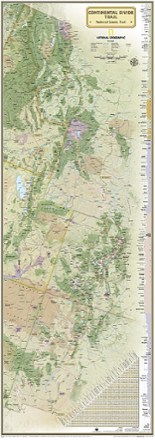
Expertly researched and designed, this National Geographic map of the Continental Divide Trail is ideal for fans and hikers of this magnificent National Scenic Trail.
Features
- This beautiful map shows the entire length of the trail from Mexico to Canada through New Mexico, Colorado, Wyoming, Idaho and Montana
- It makes a great planning tool or as reference to track progress on the 3,100-plus mile length
- A unique elevation profile highlights the trail's peaks and valleys, and an informative mileage chart shows the distance between key locations
- Also highlighted on this map are passes, peaks, national forests, national parks, state parks and Indian reservations
- Additional points of interest include lodges and campgrounds near the trail
- Map is packaged in a full color box designed for gift giving; the box includes a large image of a section of the map inside and details including size and scale
- 27% of the proceeds from the sale of this map fund the National Geographic Society's work in the areas of science, exploration, conservation and education