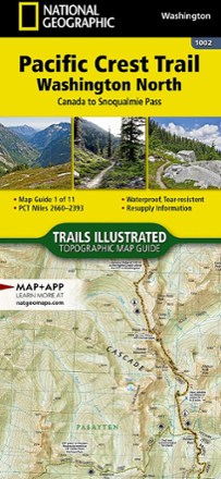


Pacific Crest Trail Topographic Map Guide: Washington North
Tech Specs
Specifications are maintained on Pack4Back GearDB (community edits and revision history). Values may differ from the manufacturer or your unit—verify before buying.
BrandNational Geographic
Best UseBackpacking
State / ProvinceWashington
Folded Dimensions9.25 x 4.25 inches
Map Scale1:75,000
Double SidedYes
WaterproofYes
PublisherNational Geographic
Copyright Year2019
Map Number1002
Description
As convenient and lightweight as folded paper maps but easier to read, this Topographic Map from National Geographic follows the Washington North portion of the Pacific Crest Trail.
Features
- Map guide 1 of 11 covers miles 2,660 to 2,393 of the PCT, from Canada to Snoqualmie Pass, at a scale of almost 1 inch : 1 mile
- Made for all levels of hiking enthusiasts, from the day tripper to the thru-hiker
- The front pages of the printed topographic map guide include resupply locations, health and safety information, and much more
- Each page is centered on the PCT and overlaps with the adjacent pages so there is little chance of getting lost
- Along the bottom of each page is a trail profile that shows the distance between camping areas, trailheads and other points of interest
- The map and trail profile provide a step-by-step visual guide to hiking the trail, mile by rugged mile
- Waterproof, tear-resistant and backcountry tough
- A full UTM grid is printed on the map to aid with GPS navigation