

Cherokee and Pisgah National Forests Topographic Map
Tech Specs
Specifications are maintained on Pack4Back GearDB (community edits and revision history). Values may differ from the manufacturer or your unit—verify before buying.
Description
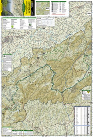
The detailed Trails Illustrated Cherokee and Pisgah National Forests topographic map offers concise and colorful coverage of the French Broad and Nolichucky rivers in Tennessee and North Carolina.
Features
- Includes Sampson Mountains Wilderness, Paint Creek Corridor and Bald Mountains
- Expertly researched and created in partnership with the National Park Service and others
- Provides valuable wilderness tips and Leave No Trace guidelines, along with updated trails, trailheads, points of interest, campgrounds and much more
- Includes selected waypoints in both Lat./Lon. and UTM coordinate systems, along with GPS-compatible UTM grid lines for easy navigation
- Easy-to-read, yet highly detailed map shows comprehensive trail and road networks, along with designated trails for hiking, horseback riding, biking and more
- Clearly marked navigational aids with UTM coordinate grids, scale bar and full legend, essential for safely navigating the backcountry with GPS or compass
- Features key points of interest such as scenic views, campgrounds, trailheads, boat launches and picnic sites
- Color-coded boundaries for public lands including national parks, national forests, national monuments, ranger districts, wilderness areas, state parks and wildlife refuges
- 1:63,360 scale
- Printed in the USA on durable, lightweight, waterproof and tear-resistant material designed to withstand all weather conditions
- Folded dimensions: 4.25 x 9.25 in.; unfolded dimensions: 25.5 x 37.75 in.
- National Geographic Maps; copyright 2000 (revised 2004)