Taos - Wild Rivers Trail Map
Tech Specs
Specifications are maintained on Pack4Back GearDB (community edits and revision history). Values may differ from the manufacturer or your unit—verify before buying.
Description
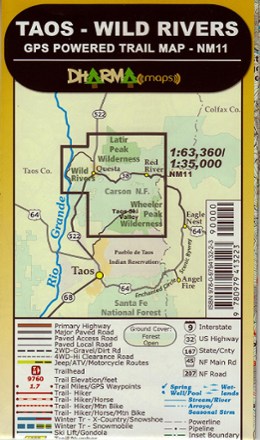
Find your way along the trail with the GPS-precision of the Dharma Maps Taos–Wild Rivers trail map, a vivid shade-relief topographic map marked with all official trails and roads in the area.
Features
- Great for all recreational activities, including hiking, mountain biking, equestrian, 4WD and winter activities like cross-country skiing, snowshoeing and snowmobiling
- All trails, roads and highways are clearly marked with subtle variations to indicate best use, recreation and road surface
- Color-coded trail difficulty ranking makes trail selection easy
- Color-shaded boundaries distinguish national parks, national forests, wilderness areas, regional/local parks and more
- Clearly defined icons mark trailheads, interpretive centers, campgrounds, parking, picnic areas, visitors centers and more
- Waterproof, double-sided maps built to withstand the rigors of frequent use on the trail