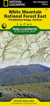

Presidential Range / Gorham Topographic Map
Tech Specs
Specifications are maintained on Pack4Back GearDB (community edits and revision history). Values may differ from the manufacturer or your unit—verify before buying.
Description
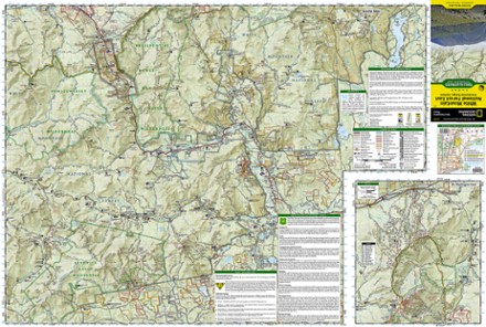
The Trails Illustrated Presidential Range / Gorham Topographic Map provides unmatched detail for outdoor enthusiasts seeking to enjoy the year-round recreational opportunities this area has to offer.
Features
- Created in partnership with local land management agencies and the Appalachian Mountain Club, this expertly researched map includes helpful contact info, safety tips and more
- Covers Echo Lake, Crawford Notch, and Grafton Notch state parks, Androscoggin River, Bretton Woods ski area, Silvio O. Conte Wildlife Refuge and Mount Chocorua Scenic Area
- Also includes a detailed inset of Mount Washington
- Easy-to-read, yet highly detailed map shows comprehensive trail and road networks, along with designated trails for hiking, horseback riding, biking and more
- Clearly marked navigational aids with UTM coordinate grids, scale bar and full legend, essential for safely navigating the backcountry with GPS or compass
- Features key points of interest such as scenic views, campgrounds, trailheads, boat launches and picnic sites
- Color-coded boundaries for public lands including national parks, national forests, national monuments, ranger districts, wilderness areas, state parks and wildlife refuges
- 1:70,000 scale
- Printed in the USA on durable, lightweight, waterproof and tear-resistant material designed to withstand all weather conditions
- Folded dimensions: 4.25 x 9.25 in.; unfolded dimensions: 37.75 x 25.5 in.
- National Geographic Maps; copyright 2011