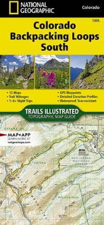


Colorado Backpacking Loops South Topographic Map Guide
Tech Specs
Specifications are maintained on Pack4Back GearDB (community edits and revision history). Values may differ from the manufacturer or your unit—verify before buying.
BrandNational Geographic
Best UseBackpacking
State / ProvinceColorado
Folded Dimensions9.25 x 4.25 inches
Unfolded DimensionsUnavailable
Map Scale1:40,680; 1:63,361
Double SidedYes
WaterproofYes
PublisherNational Geographic
Copyright Year2018
Map Number1305
Description
The Trails Illustrated Colorado Backpacking Loops South topographic map guide covers a dozen loops throughout southern Colorado, selected for their diversity, remoteness and inspiring vistas.
Features
- Each page of the guide includes a detailed map of the trail with directions to the trailhead from the nearest major town as well as a trail profile with mileages
- GPS coordinates are provided for strategic points along the trail to help with navigation
- Trails are organized by the number of nights backpackers can expect to be in the backcountry, from 1 to more than 3
- Trails range from 10 to 26 miles long with elevation gains from 2,000 to over 9,000 ft.
- Trail descriptions give an overview of the natural features you'll encounter along the way as well as the length, total elevation gain and nearest town to each trailhead
- More convenient and easier to use than folded maps, but just as compact and lightweight, map guide booklets are printed on "Backcountry Tough" waterproof, tear-resistant paper
- A full UTM grid is printed on the map to aid with GPS navigation