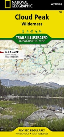


Cloud Peak Wilderness Map
Tech Specs
Specifications are maintained on Pack4Back GearDB (community edits and revision history). Values may differ from the manufacturer or your unit—verify before buying.
BrandNational Geographic
Best UseHiking
Folded Dimensions4.25 x 9.25 inches
Unfolded Dimensions37.75 x 25.5 inches
Map Scale1:45,000
Double SidedYes
WaterproofYes
PublisherNational Geographic
Copyright Year2020
State / ProvinceWyoming
Map Number720
Description
Discover the wildest section of the Bighorn Mountains with this Cloud Peak Wilderness map from National Geographic Trails Illustrated. It offers vivid detail and a waterproof, rugged construction.
Features
- Includes all 200,000 acres of the Cloud Peak Wilderness and parts of the surrounding Bighorn National Forest
- Includes key areas of interest such as Highland and Coffeen parks, Meadowlark Lake, Upper and Lower Paint Rock Lakes, Kearny Lake Reservoir, and Cloud Peak Skyway
- Details on trail mileages, trail use and seasonal closures will assist in choosing the path that's right for you
- Recreation features are clearly marked, including campgrounds, trailheads, boat launches, ski areas and other points of interest
- Features contour lines and elevations, labeled peaks and passes and hundreds of water features
- Also includes color-coded boundaries between private land, national forest and wilderness areas and no camp fire zones
- Every Trails Illustrated map is printed on "Backcountry Tough" waterproof, tear-resistant paper
- A full UTM grid is printed on the map to aid with digital navigation