
Colorado Trail Collegiate Loop Topographic Map Guide
Tech Specs
Specifications are maintained on Pack4Back GearDB (community edits and revision history). Values may differ from the manufacturer or your unit—verify before buying.
BrandNational Geographic
Best UseBackpacking
State / ProvinceColorado
Folded Dimensions9.25 x 4.25 inches
Unfolded DimensionsBooklet
Map Scale1:75,000
Double SidedYes
WaterproofYes
PublisherNational Geographic
Copyright Year2018
Map Number1203
Description
Designed for navigating the 163-mile Collegiate Loop, the National Geographic Colorado Trail Collegiate Loop topographic map guide has the info you need, whether you're backpacking or on a day hike.
Features
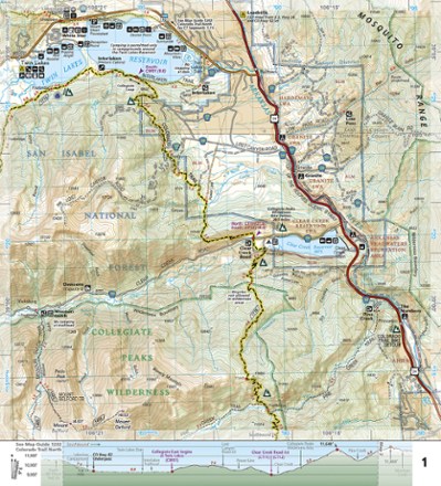
- Each page is centered on the trail and overlaps with adjacent pages, making navigation simple
- Along the bottom of each page is a trail profile that shows the distance between passes, camping areas and trail access points
- Map and trail profile provide a step-by-step visual guide to hiking the trail
- Expertly researched and created in partnership with local land management agencies including The Colorado Trail Foundation
- Provides detailed topographic maps, interesting history, bike detour maps and a 15-day itinerary
- Resupply location chart shows distances to and services available at resupply points
- Full UTM grid is printed on the map to aid with GPS navigation
- More convenient and easier to use than folded maps, this map guide booklet provides a wealth of info while still being compact and lightweight
- Printed on Backcountry Tough waterproof, tear-resistant paper with stainless steel staples