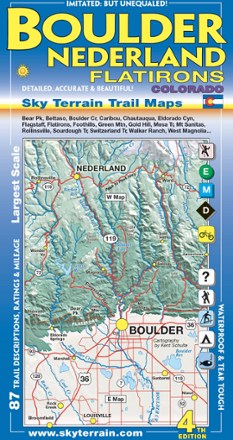
Boulder, Nederland and Flatirons Trail Map - 4th Edition
Tech Specs
Specifications are maintained on Pack4Back GearDB (community edits and revision history). Values may differ from the manufacturer or your unit—verify before buying.
Best UseNavigating
Folded Dimensions8 x 4 inches
Unfolded Dimensions39 x 24 inches
Map Scale1:33,000
Double SidedYes
WaterproofYes
PublisherSky Terrain Trail Maps
Copyright Year2014
State / ProvinceColorado
Description
Venture into the front range of the Rockies with the Sky Terrain Boulder, Nederland and Flatirons Trail Map, vividly detailed with shade relief topography and an abundance of trails to trek.
Features
- Waterproof, tear-resistant map that folds up to fit in a pocket provides durability in all conditions and can withstand years of use in hand and on the trail
- Covers Boulder, Nederland, Flatirons, Eldorado Canyon and more, spanning the open spaces, parks and national forest areas
- Color-shaded topographic relief in 50 ft. and 250 ft. contours shows the vivid detail of the stunning terrain
- Full UTM grid makes navigation easy with GPS and compass
- Information includes descriptions to 87 trails, mileage between trail junctions and color-coded difficulty rating symbols to simplify choosing your adventure
- Recreation-focused trails ideal for hiking, mountain biking, skiing, climbing, camping and fishing
- Easy-to-read symbols indicate all campgrounds and trailheads in the area, as well as mining ghost towns, waterfalls and hot springs